Production and Usage Map Tiles |
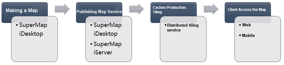
SuperMap provides a variety of tools available to split maps into map tiles for efficient access to online map services. This article will introduce the production and use process of map tiles from drawing and tiling to the use of map services from the perspective of the whole process of products, to help you simply and quickly improve the efficiency of map services through the caching mechanism.
SuperMap iDesktopX is a desktop GIS tool provided by SuperMap, which is a professional GIS data analysis, processing and mapping platform, this paper recommends the use of SuperMap iDesktopX to produce data and map, and also supports one-click publishing of map data as SuperMap iServer map services.
SuperMap iDesktopX, as a traditional mapping tool, has integrated 2D and 3D mapping capabilities, and provides rich and customizable 2D and 3D mapping symbols.
Please refer to the SuperMap iDesktopX online help for the specific method of map making.
SuperMap iDesktopX supports one-click publishing of local and remote data and maps in workspace as SuperMap iServer service. The service type can be REST service, OGC standard service, etc.
For the specific method of using SuperMap iDesktopX publish services, please refer to SuperMap iDesktopX online help.
Of course, you can also use the SuperMap iServer Publish Service.
The distributed tiling service provided by SuperMap iServer can add multiple map tiling nodes located on different machines to achieve parallel and efficient map tiling on multiple machines. The distributed map tiling service supports the map tiling of all published map name services. The data source of the service can be SuperMap workspace data, image service, remote WMS service, remote WMTS service, remote REST Map service, Bing Maps service, Tianditu service, Google Map map service, Baidu map service, OpenStreetMap map service, ArcGIS REST map service, MBTiles file, SMTiles file, and so on.
Using the distributed tiling service, you can tile the map into map tiles according to specific logic and store them in MongoDB distributed file system, you can store map tiles in .smtils files based on an extension of the MBTiles specification, and you can tile the map into GeoPackages Standard map tiles. You can also split the map into map tiles according to the SuperMap V5.0 caching strategy and store them in the local disk.
If you use the distributed tiling service for tiling, the resulting tiles are vector tiles, and map tiles stored in MongoDB which can be automatically used by the map service without additional configuration. If the map tiles are in other formats such as SMTiles, UGC, or if you have modified the default storage path or have other custom settings, you need to Configure the map services to use the existing tiles .
Therefore, we recommend using the distributed tiling service to produce map tiles. For the detailed introduction and usage of distributed tiling, please refer to: Distributed Tiling Service .
In addition, you can also create SuperMap UGC format map tiles for map services derived from workspace data using other tools, such as SuperMap iDesktopX, SuperMap iObjects.
The fundamental purpose of the server-side published map name and pre-tile map tiles is to improve the drawing efficiency of the client, so it can only play a real role when the client accesses. You can access the map services online to use these tiles, or you can directly put the tiles on the mobile terminal for offline use.
The map services provided by SuperMap iServer can be accessed through a variety of terminals, such as SuperMap iDesktopX, iObjects, iClient , and iMobile products. The pre-tile map tiles can play the role of caching when these terminals access services. But the most common usage scenario is through Web and mobile to access online map services.
For a map service and an existing tile, when the client accesses it online, the drawing request methods are as follows:
When accessing the map services of SuperMap iServer through Web or mobile terminal, if the server uses the tiled map tiles, the tiles can be called directly when plotting the map without rendering the map again, thus effectively improving the access efficiency of the online map. Currently supported Web tools: iClient for Flash, iClient for JavaScript、iClient for Silverlight、 iClient3D for Cesium , mobile tools: iMobile Lite for Android、 iMobile Lite for iOS、 iClient for Windows 8、 iMobile for iOS、 iMobile for Android.
In addition to map tiles, SuperMap iServer also provides vector tiles and attribute tiles. The combination of these three tile data can bring better user experience to mobile maps. Use the grid tile as the base map and superimpose the vector POI data rendering, together with attribute tile, realizes real-time mouse interaction of data, which not only ensures the efficiency of map base map, but also ensures the rapid update of POI and route data with high timeliness requirements, and also supports frequent mouse interaction of users.
The map services of SuperMap iServer can also be accessed on the mobile terminal through iClient or iMobile. At this time, the map tiles already tile on the server side can also play a very good role in caching. However, limited by the network speed and other factors, the download speed of tiles still cannot meet the demand when the mobile terminal accesses the map services, so the server side provides the offline application mode of map tiles. That is, map tiles is made into an offline map package (*.smtiles or *.mbtiles), directly download or copy to mobile terminals, so that map browsing is free from bandwidth constraints and help users save traffic.