SuperMap iClient 9D(2019) Product Overview
The main functions and services
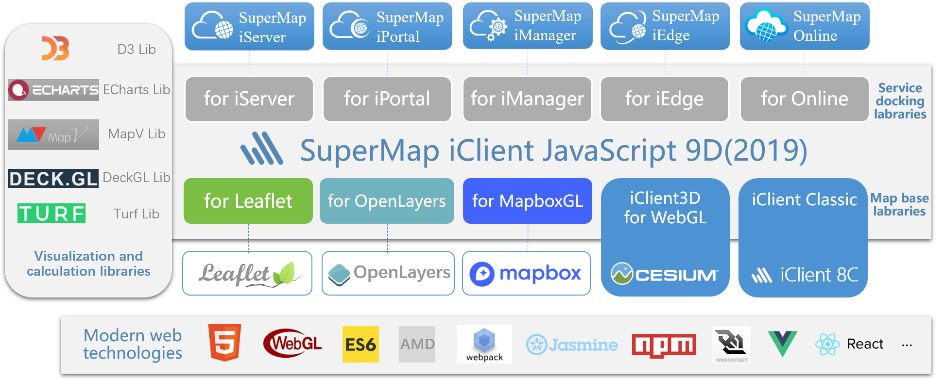
This chapter introduces the main functions and services supported by each map base library of SuperMap iClient JavaScript 9D(2019).
| Main functions and services | Map base libraries | ||||
|---|---|---|---|---|---|
| for Leaflet | for OpenLayers | for MapboxGL | iClient Classic | ||
| SuperMap iServer | √ | √ | √ | √ | |
| SuperMap iPortal | √ | √ | - | √ | |
| SuperMap Online | √ | √ | - | √ | |
| SuperMap iManager | √ | - | - | - | |
| Elasticsearch | √ | √ | √ | √ | |
| Client visualization | √ | √ | √ | √ | |
| Dynamic plotting | √ | - | - | √ | |
| Client analysis | √ | √ | √ | - | |
| Control | √ | √ | √ | √ | |
| OGC | √ | √ | √ | √ | |
| Internet map | √ | √ | √ | √ | |
Note: √ is supported, √ is partially supported, - is under development
Browser compatibility
This chapter introduces the compatibility of SuperMap iClient JavaScript 9D(2019) on mainstream browsers on the PC and mobile terminals.
| Map base library | Desktop | Mobile | ||||||||
|---|---|---|---|---|---|---|---|---|---|---|
|
Chrome |
Firefox |
IE |
Opera |
Safari |
Chrome |
Firefox |
IE |
Safari |
Android Browser |
|
| for Leaflet | 26.0+ | 23.0+ | 7-11 | 12.0+ | 5.0+ | Chrome Mobile 47+ | 55+ | 10+ for Win8 | for iOS 7+ | 2.2+, 3.1+, 4.0+ |
| for OpenLayers | 26.0+ | 23.0+ | 10.0+ | 20.0+ | 5.0+ | Chrome Mobile 47+ | 55+ | 10+ for WP7+ | Mobile Safari 9.0+ for iOS 9+ |
4.4+ |
| for MapboxGL | 23.0+ | 38.0+ | 11 on XBOX One | 20.0+ | 12 alpha+ | Chrome Mobile 47+ | 55+ | 11 for WP 7+ | Mobile Safari 9.0+ for iOS 9+ |
4.4+ |
| iClient Classic | 26.0+ | 23.0+ | 9.0+ | 20.0+ | 5.0+ | Chrome Mobile 47+ | 55+ | for WP 7.5 | for iOS 4+ | 2.1+ |
| GIS services | GIS services (data flow) |
Visualization (client thematic map) |
Visualization (ECharts) |
Visualization (MapV) |
Visualization (D3) |
Client analysis (Turf) |
Third party (Elasticsearch) |
|---|---|---|---|---|---|---|---|
| IE8+ | IE10+ | IE9+ | IE8+ | IE10+ | IE9+ | IE9+ | IE11+ |
Third-party plugins
This chapter describes the usage of third-party plugins of SuperMap iClient JavaScript 9D(2019).
| Third-party plugins | Map base library | Plugin version information | |||||
|---|---|---|---|---|---|---|---|
| for Leaflet | for OpenLayers | for MapboxGL | iClient Classic | The latest version | Release / latest submission time | Currently used version | |
| Leaflet | √ | - | - | - | v1.3.4 | 2018-08-21 | v1.3.1 |
| Leaflet.heat | √ | - | - | - | v0.2.0 | 2016-09-30 | v0.2.0 |
| Leaflet.markercluster | √ | - | - | - | v1.4.1 | 2018-09-14 | v1.3.0 |
| Leaflet.draw | √ | - | - | - | v1.0.3 | 2018-09-15 | v1.0.2 |
| leaflet.pm | √ | - | - | - | v0.25.0 | 2018-09-15 | v0.25.0 |
| leaflet-icon-pulse | √ | - | - | - | v0.1.0 | 2017-09-06 | v0.1.0 |
| Leaflet.D3SvgOverlay | √ | - | - | - | v2.2.0 | 2017-10-13 | v2.2.0 |
| Leaflet-MiniMap | √ | - | - | - | v3.6.1 | 2018-03-02 | v3.6.1 |
| leaflet-side-by-side | √ | - | - | - | v2.0.0 | 2017-08-05 | v2.0.0 |
| openlayers | - | √ | - | - | v5.2.0 | 2018-08-29 | v4.6.5 |
| OL3-AnimatedCluster | - | √ | - | - | - | 2018-07-04 | - |
| ol-mapbox-style | - | √ | - | - | v2.11.2 | 2018-05-28 | v2.11.2 |
| ol3-echarts | - | √ | - | - | v1.3.4 | 2018-07-31 | v1.3.4 |
| mapbox-gl-js | - | - | √ | - | v0.49.0 | 2018-09-13 | v0.48.0 |
| mapbox-gl-draw | - | - | √ | - | v1.0.9 | 2018-05-10 | v1.0.9 |
| mapbox-gl-compare | - | - | √ | - | v0.2.0 | 2018-08-04 | v0.1.0-dev |
| echartsLayer | - | - | √ | - | - | 2017-12-04 | - |
| shapefile | - | - | √ | - | v0.6.6 | 2017-09-03 | v0.6.6 |
| echarts | √ | √ | √ | - | v4.2.0-rc.1 | 2018-09-15 | v4.1.0 |
| mapv | √ | √ | √ | √ | v2.0.20 | 2018-8-27 | v2.0.20 |
| turf | √ | √ | - | - | v5.1.6 | 2017-12-11 | v5.1.6 |
| elasticsearch | √ | √ | √ | √ | v15.1.1 | 2018-07-04 | v15.0.0 |
| osmbuildings-OL3 | √ | √ | - | - | v0.2.2b | 2014-11-25 | v0.2.2b |
| osmbuildings-Leaflet | √ | √ | - | - | v0.2.2b | 2014-11-25 | v0.2.2b |
| d3 | √ | - | - | - | v5.7.0 | 2018-08-25 | v5.5.0 |
| d3-hexbin | √ | - | - | - | v0.2.2 | 2017-03-29 | v0.2.2 |
| deck.gl | √ | √ | √ | - | v5.1.4 | 2018-03-24 | v5.1.3 |
| js-xlsx | √ | - | - | - | v0.14.0 | 2018-09-06 | v0.12.13 |
| dat.gui | - | √ | - | - | v0.7.2 | 2018-05-06 | v0.6.5 |
| proj4js | - | - | √ | - | v2.5.0 | 2018-08-25 | v2.4.3 |
Note: 1. Third-party plugin version information statistics in Sep. 2018
2. Some plugins did not provide the release version and release time, then its latest submission date shall prevail
License
This chapter describes the license agreements involved in SuperMap iClient JavaScript 9D(2019) related third-party plugins.
How to choose
This chapter introduces how to choose the map base library of SuperMap iClient JavaScript 9D(2019).
| Indicators | Map base library and corresponding open source map client | ||||
|---|---|---|---|---|---|
| for Leaflet | for OpenLayers | for MapboxGL | iClient Classic | ||
| Leaflet | OpenLayers 3/4 | MapboxGL | OpenLayers 2 | ||
| Open source license | BSD-2-Clause | BSD-2-Clause | BSD-3-Clause | BSD-2-Clause | |
| Closed-source risk | no | no | no | no | |
| Advantage | Lightweight , Rich plugins |
HTML5 , OL-Cesium |
MVT vector tile Display effect |
More users , High stability |
|
| Disadvantages | Plugin stability is uneven | Heavier , Less plugins |
Only support 3857 coordinate system | Outdated framework | |
| Performance | Medium | High | High | Low | |
| stability | High | medium | medium | High | |
| Extendibility | Well | Better | Poor | Better | |
| Document | Better , (Without Chinese) |
Better , (Without Chinese) |
Better , (Without Chinese) |
Well , (Chinese API doc) |
|
| Community activity | Stars | 22,763 | 4,056 | 3,442 | 1,493 |
| Contributors | 581 | 223 | 212 | 102 | |
| Commits | 6,636 | 24,224 | 8,365 | 7,248 | |
| Pull Requests | 73 | 49 | 24 | 150 | |
| Issues | 294 | 559 | 490 | 391 | |
| Forks | 3,769 | 1,683 | 870 | 813 | |
| Software maturity | high | Medium | Medium | General | |
| Community ecology | well | Better | The initial stage | Better | |
| Learning costs | Medium | High | Medium | High | |
Note: The community activity statistics in Sep. 2018
Summary statement:
The community activity of any open source software product determines the maturity, vitality, future prospects and other characteristics of the product. It also determines whether or not to establish a R & D - application - service ecosystem.
- Leaflet map libraries are lightweight, feature rich plugins, and have a high degree of community activity, and it is better in stability and scalability.
- The Openlayers 3/4 map library is heavyweighted, with a moderate level of community activity, but with better expansibility and scalability and support for HTML5 features.
- MapboxGL launched later than the previous two map libraries,community activity in general, only supports 3857 coordinate system at this stage. Its scalability is poor, but it supports 3D features and better visualization.